Difference between revisions of "Maps"
From Carrick-Overbrook Historical Society
(→This is a 1912 map of Carrick Borough illustrating the original names and many new plans from that on the 1905 map. For detailed streets it has not been reduced in size, if you click on the map you can see all the detail in a new window.) |
|||
| (3 intermediate revisions by the same user not shown) | |||
| Line 2: | Line 2: | ||
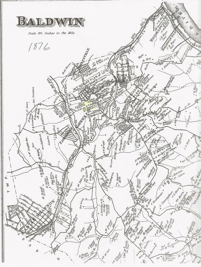
| − | == This 1905 Carrick Borough map is now framed and hanging on the "Carrick Room" of the Carrick Branch of the Carnegie Library of Pittsburgh. See [Pittsburgh Leader 1904]for the full story of Carrick Borough breaking away from Baldwin Township on [June 21, 1904]. == | + | == This is an 1876 map of Baldwin Township illustrating Carrick and Overbrook before they became boroughs. == |
| + | |||
| + | [[Image:Baldwin Map 1876.jpg]] | ||
| + | |||
| + | |||
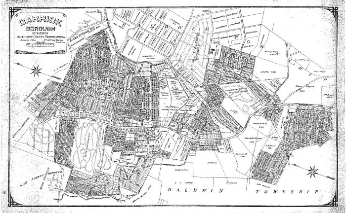
| + | == This 1905 Carrick Borough map is now framed and hanging on the "Carrick Room" of the Carrick Branch of the Carnegie Library of Pittsburgh. See [[Pittsburgh Leader 1904]] for the full story of Carrick Borough breaking away from Baldwin Township on [[June 21, 1904]]. == | ||
[[Image:1905 carrick map.JPG]] | [[Image:1905 carrick map.JPG]] | ||
| + | |||
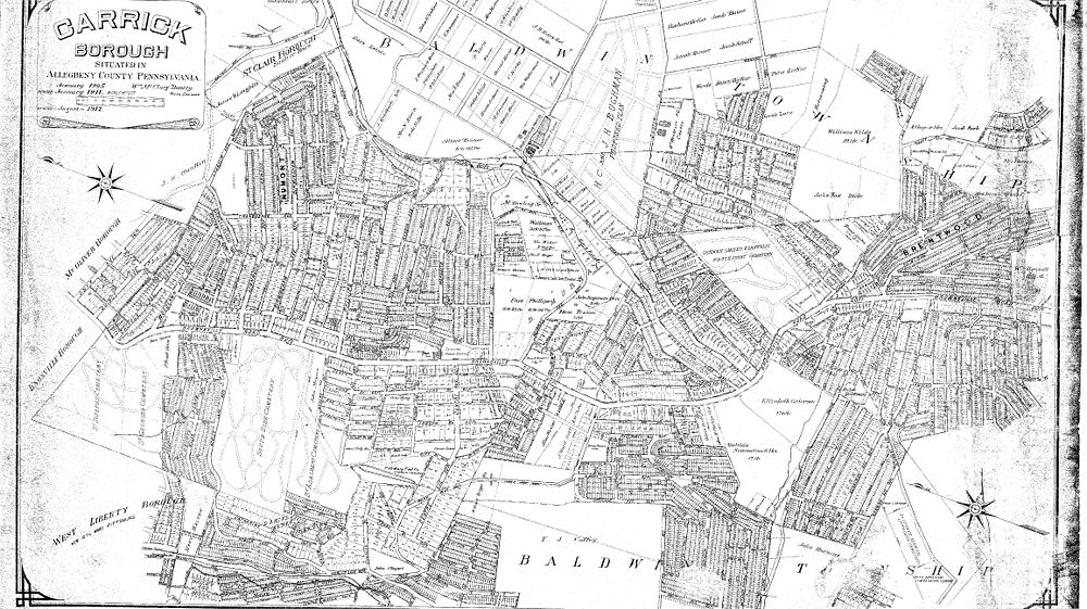
| + | == This is a 1912 map of Carrick Borough illustrating the original names and many new plans from that on the 1905 map. For detailed streets it has not been reduced in size, if you click on the map you can see all the detail in a new window. Map courtesy of Nick Markowitz.== | ||
| + | |||
| + | [[Image:1912 map of Carrick.jpg|1000px]] | ||
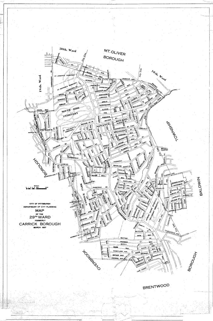
== This is a 1927 Carrick map marking the boundaries of the 29th ward of the City of Pittsburgh. Carrick bacame part of the city after a vote in 1927 agreeing to become the newest and largest neighborhood in Pittsburgh. == | == This is a 1927 Carrick map marking the boundaries of the 29th ward of the City of Pittsburgh. Carrick bacame part of the city after a vote in 1927 agreeing to become the newest and largest neighborhood in Pittsburgh. == | ||
Latest revision as of 11:41, 9 September 2010
Contents
- 1 This section contains a collection of maps of Carrick.
- 2 This is an 1876 map of Baldwin Township illustrating Carrick and Overbrook before they became boroughs.
- 3 This 1905 Carrick Borough map is now framed and hanging on the "Carrick Room" of the Carrick Branch of the Carnegie Library of Pittsburgh. See Pittsburgh Leader 1904 for the full story of Carrick Borough breaking away from Baldwin Township on June 21, 1904.
- 4 This is a 1912 map of Carrick Borough illustrating the original names and many new plans from that on the 1905 map. For detailed streets it has not been reduced in size, if you click on the map you can see all the detail in a new window. Map courtesy of Nick Markowitz.
- 5 This is a 1927 Carrick map marking the boundaries of the 29th ward of the City of Pittsburgh. Carrick bacame part of the city after a vote in 1927 agreeing to become the newest and largest neighborhood in Pittsburgh.
This section contains a collection of maps of Carrick.
This is an 1876 map of Baldwin Township illustrating Carrick and Overbrook before they became boroughs.
This 1905 Carrick Borough map is now framed and hanging on the "Carrick Room" of the Carrick Branch of the Carnegie Library of Pittsburgh. See Pittsburgh Leader 1904 for the full story of Carrick Borough breaking away from Baldwin Township on June 21, 1904.


