Difference between revisions of "Hornaday Road"
| Line 1: | Line 1: | ||
| − | |||
| − | + | == This is my introduction and short history of the origins of The Carrick-Overbrook Historical Society along with my first order of business was to be what I will title '''"The Hornaday Road Report”''' == | |
| − | John Rudiak and I, | + | |
| + | John Rudiak and I, Joe Krynock, were discussing our street’s historical background at the 2007 Hornaday Road block party. This is an annual neighborhood gathering where neighbors get together. Recently retired and with time on his hands, John mentioned that he was going to the Recorder of Deeds office to research deed information. Since I also wanted to explore my home’s past and to determine a build date, John and I decided to work together. I had researched deeds before but that seemed a very long time ago. As we talked more during the block party, other neighbors mentioned historic information about their homes, or rumored information of our Hornaday Road neighborhood. Even with these scattered tidbits of information not many knew specific details for sure. Since John had already been living here since 1976 when I moved into Carrick in 1982, I thought John knew more historic details about Hornaday Road than me. | ||
"Not really" he said. | "Not really" he said. | ||
| − | I told him that | + | I told him that a Pittsburgh Councilman named Phillips was a friend of William T. Hornaday. In fact; when they were not hunting together, they promoted stuff like Boy Scouting, better zoos and conservation. |
| − | + | “Our Hornaday,” John asked “Who was he?” | |
| − | + | I responded that William T. Hornaday was a conservationist writer but he was also a taxidermist and the director at the Bronx, New York zoo and that I found this out by accident. Years ago I bought a bargain priced book titled “Buck Fever” because it written by Mike Sajna, now deceased, an writer that I recognized. Mike Sajna's book was printed by the University of Pittsburgh Press and it was about deer hunting and the Pennsylvania Game Commission history. In that book there were the names of John M. Phillips and William T. Hornaday. We talked about that and I stated that I wanted to investigate that small bit of information, someday soon. John noted that I was retired so now was as good a time to start as ever. | |
| − | + | The next day after our block party I found my copy of “Buck Fever” and re-read pages 68 to 78 to refresh my memory and sure enough the clues to our history where there. Then I then suggested to John that perhaps together we could collaborate on a Hornaday Road history project and we could do a story or report for our neighbors and friends before the next year’s block party in 2008. | |
| − | + | With these few clues we started our search. John and I started at the Recorder of Deeds office downtown and we pulled dozens of dusty Deed books to track our own property records. We spent most of a day there when John found some very interesting information about J. B. Murray's housing plan laid out in December 1859 and made copies for later reference. | |
| − | + | ||
| − | + | ||
| − | + | ||
| − | + | ||
| − | + | ||
| − | + | ||
| − | + | ||
| − | + | ||
| − | + | ||
| − | + | ||
| − | With these few clues we started | + | |
[[Image:1859 J.B.jpg]] | [[Image:1859 J.B.jpg]] | ||
| − | + | And then we found this map and its information was related to all of the homes and owners in the area which raised more questions for us. | |
| − | + | ||
| − | + | ||
| − | + | ||
| − | + | ||
| − | + | ||
| − | + | ||
| − | + | ||
[[Image:1905 j.b.murray plan.jpg]] | [[Image:1905 j.b.murray plan.jpg]] | ||
| − | + | A short time later we went to the Carrick Library and we asked if they had any local historical information there. Julia Kuchta, librarian, showed us the file cabinets in one corner of the community room. Pleasantly surprised we found that Mr. Joe Spiecker, a local historian along with help from Mrs. Audrey Dawida, sorted and archived local history for close to twenty years. Joe and Audrey had assembled many binders of information, which we perused. Interestingly the information was not touched for a long time but John found a crumpled piece of paper, with something inside it. It was a Volunteer Fireman’s badge from when Carrick was a borough. We both felt that this item was not just rare but of great historic importance to the community, too important to just be lying in a file drawer easily lost. John immediately brought it to Julia’s attention asking if there was a secure storage location for it. As we looked at the collection of photos and articles, we found missing and misplaced as to page numbers. John commented that if all this stuff was scanned and digitized it would be easier to protect, store, document and collect. To give you an idea of what we found there were photostatic copies of old photos, some original photos, news articles and papers, loose papers all lying at the bottom of drawer; perhaps they fell out or ransacked or they just were never identified and mounted. Joe Speiker was contacted but he said he lost interest and was in ill health at the time, but asked us to take care of his collection. | |
| − | + | ||
| − | + | A carpenter by trade computer work is not what I did for a living and I felt that my plan for a short historical letter to the neighbors had suddenly thrust me into much deeper waters than I had intended. John suggested that instead of making and saving copies of our findings which would have amounted to reams of paper that we digitize it all into a website for anyone to review, not just Hornaday residents, to explore in their own time and leisure. So it was John who took me into this new and uncharted internet territory with the website idea. | |
| − | + | Often and independently, we looked for maps and stuff on internet sites. I found the Historic Pittsburgh Project online and among their sources and maps was the survey map dated 1905. It showed that a John Phillips had owned a “piano” shaped piece of land which had his mansion on it and it faced Southern Avenue, also known as Brownsville Road, The Brownsville Plank Road, or The Brownsville Road. | |
| − | + | John Phillips’ mansion sat on Lot 3 set back from Brownsville Road centered where the current Hornaday Road is now and his “Governor’s style” curved driveway was likely for his horse drawn carriages and curved away from his home to meet the streets that we know as East Agnew Avenue and Madeline Street. I will assume it may have been built about the time of the Civil war. | |
| − | + | ||
| − | + | [[Image:John Phillips Hornaday Homestead-1.jpg]] | |
| − | + | A close examination of the Carrick post card photo of John Phillips home, provided by Carol Anthony of the South Pittsburgh Historical Group, reveals a platform and a telescope pointed skyward at the center of the roof. | |
| − | + | [[Image:Mansion close up 1905.jpg]] | |
| − | + | As the map shows, John Phillips mansion and his property extended, east to the Rehman family property from The Southern Ave. So, at one time, before there was a “Hornaday road” John Phillips owned an area that was eventually divided into lots for eighty homes. His mansion was on the entire flat top area with home addresses from 95 to 163. This section was a part of the "Phillips Manor Plan", laid out in October of 1915, by John M. Phillips. The original plan included the boundaries of Rehman Street and Murray Street (now Madeline) and Scout Avenue. In October of 1926, John M. Phillips, John Phillips’ nephew, once again laid out the Phillips Manor Plan revision, of lots 98 to 118 inclusive, in order to provide an alley way to those homes which he called Revision Way. It is estimated to have about 18 acres in all. | |
| − | + | As noted Hornaday Road did not exist according to this 1905 map, though plans for our homes and lots were done by J. B. Murray in 1859 and according to that 1859 map John Phillips only owned lots 1 thru 7. It should be easy for Hornaday residents to imagine our road thru the center of his mansion and property eastward to the slight bend and then downhill beginning at Rehman Street. In 1915, this road was called Waltman Street and lead down to August Waldman's farm, where it met Stevenson Street which was renamed Dowling in 1916. | |
| − | + | ||
| − | + | ||
| − | + | ||
| − | + | ||
| − | + | ||
[[Image:1916 hornaday.JPG]] | [[Image:1916 hornaday.JPG]] | ||
| − | + | On Stevenson Street nine lots were laid out by the Carrick Borough School Directors on November 19, 1915, for the third location of Concord Elementary School. These lots sit on the southside Dowling Street. | |
| − | + | The Rihman Heirs, note spelling change to Rehman Street, laid out seven lots from Hornaday Road to Madaline Street on the eastern side of that street. Some name changes so far noticed have been due to ownership changes, but some others like Rehman from the original Rihman, may be due to pronouncment variations at that time. Possibly these names were "Americanized" to resolve pronunciation problems, I am surmising. | |
| − | + | Continuing the list of land owners involved with Hornaday Road at that time, we find the Bielau plan of lots beginning with addresses 201 downhill to approximately 229. The Bielau property was on the left or north side of the downhill section, with the Benarding property down to Dowling Street (note Concord school number 3 of 5 properties on lot 11.) Bernarding owned lots adjoining these, additional odd numbered addresses 231 to 251. | |
| + | Directly on the opposite, on the southern side were lots that were divided from August Waldman’s farm. In fact, this section of our road was called Waldman until several zoning changes were made in 1913. John noted that J. B. MURRAY owned this area at one time and his name is prominent in italic text on many early maps of this area. We found that his original plan was to connect Agnew and Hornaday road with another 364 foot long section of Red Rose Avenue. This would have made all three sections of Red Rose Avenue 1,202 feet long. But that would have required eliminating 219 Hornaday Road and 217 Agnew Avenue, which are the property lots between Agnew Avenue and Hornaday Road. | ||
| − | + | Eliza Weber owned all the lots on the eastern side of Redrose Avenue. At this time 10 houses facing Redrose Avenue and perhaps four more facing Hornaday share her original property. Roughly speaking, fourteen of the 22 addresses listed on this street seem to have been built by the same builder and possibly many more in the years around 1927. There are older homes, dated from 1876,1900,1904,1907 and 1910, if county records were always correct. | |
| − | + | Also shown on the accompanying plan of lots, William F Seiger owned approximately two acres which was divided into 14 parcels. Ten lots were on the western side of Redrose and four lots were to face Hornaday. Two homes, at 218 and 220 Hornaday were built on lots three and four. My home at 216 was built on lots one and two. | |
| − | + | Other items we found in our research to date: | |
| − | + | ||
| − | + | Prior to 1927 this area, was known as Carrick Borough which was at one time part of Baldwin Township. Lower Saint Clair Township is also found on some deeds. Carrick Borough by 1926 vote was officially annexed into the city of Pittsburgh in 1927. The old and narrow borough building is at 1808 Brownsville Road. Before 1927, Carrick was very progressive under the guidance of very knowledgeable and foresighted leadership. Carrick already had the first sewerage system in western Pennsylvania. Just take a short step out onto Hornaday Road to see the Carrick Boro logos on all the manholes. Here are several photos of manhole covers that John Rudiak found and photographed. | |
| − | + | We learned from the John Heinz Historical Center that John Phillips was vice president of Oliver Iron and Steel Company, also formerly known as Lewis and Phillips on the South side at 12th street on the Monongahela River. John Phillips had a son in 1864, also named John with no middle initial. At this point in time in our investigations not much else is known about him. | |
| − | + | John MacFarlane Phillips, mentioned previously, is our connection to William T. Hornaday. John M. Phillips was not the son but a nephew of John Phillips and was the Vice President of Oliver Iron and Steel Company. A better explanation follows and is from Mike Sajna’s book “Buck Fever.” (see pg 69) | |
| − | + | “John MacFarlane Phillips was born February 15, 1861. He was the son of James Phillips, one of the founders of the Oliver Iron and Steel Company, whose own father had come to Western Pennsylvania from Northern Ireland in 1795 to work as a blacksmith. Phillips attended public schools and then studied engineering and was made superintendent of the bolt works and forging plants of the Lewis Oliver and Phillip’s company. Later he became manager of the company’s mining equipment department and in 1899, with his Uncle John, purchased the company’s mine supply division and established the Phillip’s mine and Mill supply company. He was that company’s President one year later (1890).” | |
| − | + | ||
| − | + | ||
| − | John | + | At this point of my history search, I do not know exactly when John M. Phillips and William T. Hornaday met but I do know that he and Hornaday were hunting together in British Columbia in 1901. They were involved in many aspects of game protection and the mad rush to the west had nearly wiped out all fur bearers, most notably the buffalo and the beavers. |
| + | There are references in various news articles that John M. Phillips was married at that time and took his new bride, Harriet Duff Phillips, to a ranch, where they stayed for a month. Hornaday and Phillips were in Colorado by 1903, by 1906 Phillips was an illustrator for another of Hornaday’s many conservation minded books on of which is titled “ Campfire in the Canadian Rockies. ” | ||
| − | + | In 1907 they were in Mexico and as they had done before Hornaday and Phillips donated even more stuffed animals from their hunts for displays in Museums. At the Carnegie Museum of Natural History in Oakland at least one of Phillips’ displays remains in the hall of mammals. It is a glass enclosure displaying a family of Cheetahs. However, sharing time together can lead to common interests: zoos, conservation, camping and hunting which helped bring these men together, although there was a seven year age difference between them. Hornaday and Phillips realized that outdoor training and conservation awareness could be fostered in youth through Boy Scouting. They were not alone in their thinking and according to Mike Sajna John M. Phillips organized the First Boy Scout troop in Pennsylvania in 1910. It was the second such troop in America. Phillips provided its members with a place to meet in his home at 2336 Brownsville road. This location is now the site of Saint Piux Church and small remnants of the original “castellated” stone wall remains between the church and Concord Elementary School. In front of the Church the wall had been lowered but it returns to its original “castellated” height and location in front of the home to the right of the church. Phillips’ home was also used for the celebration of many church services until 1959 when it was demolished for the new church. | |
| − | + | ||
| − | + | ||
| − | + | ||
| − | + | ||
| − | + | ||
| − | + | ||
| − | + | ||
| − | In 1907 they were in Mexico and as they had done before | + | |
| − | + | ||
| − | + | ||
| − | + | ||
| − | + | ||
| − | + | ||
| − | + | ||
| − | + | ||
| − | + | In its borough days, Carrick also had the first filtered water supply in western Pennsylvania; with 180 pounds per square inch of pressure; coming from the South Pittsburgh water plant, located at Beck’s Run Road, site of Hays Mine. Carrick Borough and its wealthy businessmen had already begun paving its streets with planks of wood three inches thick and four feet wide along with sidewalks. John M. Phillips, for the most part paid for the widening of Brownsville Road to a 60 foot right-of-way from Becks Run Road to 2331 Brownsville Road Mt Oliver. | |
| − | + | Once annexed into the city, some street names were changed to avoid duplication of existing street names in use elsewhere in Pittsburgh. Murray Street became Madeline Street and the original bend in Murray Ave (look between Murray’s “Rs” on the 1905 map) has since been straightened. Beck’s Avenue is Agnew and was also a township road in Baldwin Township until 1927. | |
| − | + | Take a look at The Crailo Plan, The Southern Avenue Land Company on the 1905 map, just north of Hornaday Road homes. This area was owned by John Agnew, beginning with its narrow lots on the north side of the street that still bears his name. One of my early assumptions about this area which have been proved correct is that this fifty two acre parcel of land was given to John Agnew and his wife and her father which Agnew and Chambers operated a glass works there. I contacted, Susan Buyers, an Agnew relative, to ask if Agnew and Chambers had taken over Engleart Glass, the first glass factory in Pittsburgh. She did not verify that question but if she had another early historic puzzle piece would fall into place. John Agnew’s new home, likely faced the Southern Road, AKA Brownsville Road, after looking at a drawing of that house. We think that it is located where the BP gas station is today. If Agnew also had his South Side glass factory, this older Engleart site was razed and resold in small lots, perhaps many of these new residents were employees at his South Side glass works. | |
| − | + | The name of Engleartville was the local name of Carrick prior to 1853, when Dr. John O’Brien established the first post office naming it Carrick after his home town of Carrick-on-Suir, Tipperary County, Ireland. | |
Revision as of 12:51, 3 July 2008
This is my introduction and short history of the origins of The Carrick-Overbrook Historical Society along with my first order of business was to be what I will title "The Hornaday Road Report”
John Rudiak and I, Joe Krynock, were discussing our street’s historical background at the 2007 Hornaday Road block party. This is an annual neighborhood gathering where neighbors get together. Recently retired and with time on his hands, John mentioned that he was going to the Recorder of Deeds office to research deed information. Since I also wanted to explore my home’s past and to determine a build date, John and I decided to work together. I had researched deeds before but that seemed a very long time ago. As we talked more during the block party, other neighbors mentioned historic information about their homes, or rumored information of our Hornaday Road neighborhood. Even with these scattered tidbits of information not many knew specific details for sure. Since John had already been living here since 1976 when I moved into Carrick in 1982, I thought John knew more historic details about Hornaday Road than me.
"Not really" he said.
I told him that a Pittsburgh Councilman named Phillips was a friend of William T. Hornaday. In fact; when they were not hunting together, they promoted stuff like Boy Scouting, better zoos and conservation.
“Our Hornaday,” John asked “Who was he?”
I responded that William T. Hornaday was a conservationist writer but he was also a taxidermist and the director at the Bronx, New York zoo and that I found this out by accident. Years ago I bought a bargain priced book titled “Buck Fever” because it written by Mike Sajna, now deceased, an writer that I recognized. Mike Sajna's book was printed by the University of Pittsburgh Press and it was about deer hunting and the Pennsylvania Game Commission history. In that book there were the names of John M. Phillips and William T. Hornaday. We talked about that and I stated that I wanted to investigate that small bit of information, someday soon. John noted that I was retired so now was as good a time to start as ever.
The next day after our block party I found my copy of “Buck Fever” and re-read pages 68 to 78 to refresh my memory and sure enough the clues to our history where there. Then I then suggested to John that perhaps together we could collaborate on a Hornaday Road history project and we could do a story or report for our neighbors and friends before the next year’s block party in 2008.
With these few clues we started our search. John and I started at the Recorder of Deeds office downtown and we pulled dozens of dusty Deed books to track our own property records. We spent most of a day there when John found some very interesting information about J. B. Murray's housing plan laid out in December 1859 and made copies for later reference.

And then we found this map and its information was related to all of the homes and owners in the area which raised more questions for us.

A short time later we went to the Carrick Library and we asked if they had any local historical information there. Julia Kuchta, librarian, showed us the file cabinets in one corner of the community room. Pleasantly surprised we found that Mr. Joe Spiecker, a local historian along with help from Mrs. Audrey Dawida, sorted and archived local history for close to twenty years. Joe and Audrey had assembled many binders of information, which we perused. Interestingly the information was not touched for a long time but John found a crumpled piece of paper, with something inside it. It was a Volunteer Fireman’s badge from when Carrick was a borough. We both felt that this item was not just rare but of great historic importance to the community, too important to just be lying in a file drawer easily lost. John immediately brought it to Julia’s attention asking if there was a secure storage location for it. As we looked at the collection of photos and articles, we found missing and misplaced as to page numbers. John commented that if all this stuff was scanned and digitized it would be easier to protect, store, document and collect. To give you an idea of what we found there were photostatic copies of old photos, some original photos, news articles and papers, loose papers all lying at the bottom of drawer; perhaps they fell out or ransacked or they just were never identified and mounted. Joe Speiker was contacted but he said he lost interest and was in ill health at the time, but asked us to take care of his collection.
A carpenter by trade computer work is not what I did for a living and I felt that my plan for a short historical letter to the neighbors had suddenly thrust me into much deeper waters than I had intended. John suggested that instead of making and saving copies of our findings which would have amounted to reams of paper that we digitize it all into a website for anyone to review, not just Hornaday residents, to explore in their own time and leisure. So it was John who took me into this new and uncharted internet territory with the website idea.
Often and independently, we looked for maps and stuff on internet sites. I found the Historic Pittsburgh Project online and among their sources and maps was the survey map dated 1905. It showed that a John Phillips had owned a “piano” shaped piece of land which had his mansion on it and it faced Southern Avenue, also known as Brownsville Road, The Brownsville Plank Road, or The Brownsville Road.
John Phillips’ mansion sat on Lot 3 set back from Brownsville Road centered where the current Hornaday Road is now and his “Governor’s style” curved driveway was likely for his horse drawn carriages and curved away from his home to meet the streets that we know as East Agnew Avenue and Madeline Street. I will assume it may have been built about the time of the Civil war.

A close examination of the Carrick post card photo of John Phillips home, provided by Carol Anthony of the South Pittsburgh Historical Group, reveals a platform and a telescope pointed skyward at the center of the roof.
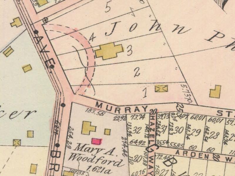

As the map shows, John Phillips mansion and his property extended, east to the Rehman family property from The Southern Ave. So, at one time, before there was a “Hornaday road” John Phillips owned an area that was eventually divided into lots for eighty homes. His mansion was on the entire flat top area with home addresses from 95 to 163. This section was a part of the "Phillips Manor Plan", laid out in October of 1915, by John M. Phillips. The original plan included the boundaries of Rehman Street and Murray Street (now Madeline) and Scout Avenue. In October of 1926, John M. Phillips, John Phillips’ nephew, once again laid out the Phillips Manor Plan revision, of lots 98 to 118 inclusive, in order to provide an alley way to those homes which he called Revision Way. It is estimated to have about 18 acres in all.
As noted Hornaday Road did not exist according to this 1905 map, though plans for our homes and lots were done by J. B. Murray in 1859 and according to that 1859 map John Phillips only owned lots 1 thru 7. It should be easy for Hornaday residents to imagine our road thru the center of his mansion and property eastward to the slight bend and then downhill beginning at Rehman Street. In 1915, this road was called Waltman Street and lead down to August Waldman's farm, where it met Stevenson Street which was renamed Dowling in 1916.

On Stevenson Street nine lots were laid out by the Carrick Borough School Directors on November 19, 1915, for the third location of Concord Elementary School. These lots sit on the southside Dowling Street.
The Rihman Heirs, note spelling change to Rehman Street, laid out seven lots from Hornaday Road to Madaline Street on the eastern side of that street. Some name changes so far noticed have been due to ownership changes, but some others like Rehman from the original Rihman, may be due to pronouncment variations at that time. Possibly these names were "Americanized" to resolve pronunciation problems, I am surmising.
Continuing the list of land owners involved with Hornaday Road at that time, we find the Bielau plan of lots beginning with addresses 201 downhill to approximately 229. The Bielau property was on the left or north side of the downhill section, with the Benarding property down to Dowling Street (note Concord school number 3 of 5 properties on lot 11.) Bernarding owned lots adjoining these, additional odd numbered addresses 231 to 251.
Directly on the opposite, on the southern side were lots that were divided from August Waldman’s farm. In fact, this section of our road was called Waldman until several zoning changes were made in 1913. John noted that J. B. MURRAY owned this area at one time and his name is prominent in italic text on many early maps of this area. We found that his original plan was to connect Agnew and Hornaday road with another 364 foot long section of Red Rose Avenue. This would have made all three sections of Red Rose Avenue 1,202 feet long. But that would have required eliminating 219 Hornaday Road and 217 Agnew Avenue, which are the property lots between Agnew Avenue and Hornaday Road.
Eliza Weber owned all the lots on the eastern side of Redrose Avenue. At this time 10 houses facing Redrose Avenue and perhaps four more facing Hornaday share her original property. Roughly speaking, fourteen of the 22 addresses listed on this street seem to have been built by the same builder and possibly many more in the years around 1927. There are older homes, dated from 1876,1900,1904,1907 and 1910, if county records were always correct.
Also shown on the accompanying plan of lots, William F Seiger owned approximately two acres which was divided into 14 parcels. Ten lots were on the western side of Redrose and four lots were to face Hornaday. Two homes, at 218 and 220 Hornaday were built on lots three and four. My home at 216 was built on lots one and two.
Other items we found in our research to date:
Prior to 1927 this area, was known as Carrick Borough which was at one time part of Baldwin Township. Lower Saint Clair Township is also found on some deeds. Carrick Borough by 1926 vote was officially annexed into the city of Pittsburgh in 1927. The old and narrow borough building is at 1808 Brownsville Road. Before 1927, Carrick was very progressive under the guidance of very knowledgeable and foresighted leadership. Carrick already had the first sewerage system in western Pennsylvania. Just take a short step out onto Hornaday Road to see the Carrick Boro logos on all the manholes. Here are several photos of manhole covers that John Rudiak found and photographed.
We learned from the John Heinz Historical Center that John Phillips was vice president of Oliver Iron and Steel Company, also formerly known as Lewis and Phillips on the South side at 12th street on the Monongahela River. John Phillips had a son in 1864, also named John with no middle initial. At this point in time in our investigations not much else is known about him.
John MacFarlane Phillips, mentioned previously, is our connection to William T. Hornaday. John M. Phillips was not the son but a nephew of John Phillips and was the Vice President of Oliver Iron and Steel Company. A better explanation follows and is from Mike Sajna’s book “Buck Fever.” (see pg 69)
“John MacFarlane Phillips was born February 15, 1861. He was the son of James Phillips, one of the founders of the Oliver Iron and Steel Company, whose own father had come to Western Pennsylvania from Northern Ireland in 1795 to work as a blacksmith. Phillips attended public schools and then studied engineering and was made superintendent of the bolt works and forging plants of the Lewis Oliver and Phillip’s company. Later he became manager of the company’s mining equipment department and in 1899, with his Uncle John, purchased the company’s mine supply division and established the Phillip’s mine and Mill supply company. He was that company’s President one year later (1890).”
At this point of my history search, I do not know exactly when John M. Phillips and William T. Hornaday met but I do know that he and Hornaday were hunting together in British Columbia in 1901. They were involved in many aspects of game protection and the mad rush to the west had nearly wiped out all fur bearers, most notably the buffalo and the beavers.
There are references in various news articles that John M. Phillips was married at that time and took his new bride, Harriet Duff Phillips, to a ranch, where they stayed for a month. Hornaday and Phillips were in Colorado by 1903, by 1906 Phillips was an illustrator for another of Hornaday’s many conservation minded books on of which is titled “ Campfire in the Canadian Rockies. ”
In 1907 they were in Mexico and as they had done before Hornaday and Phillips donated even more stuffed animals from their hunts for displays in Museums. At the Carnegie Museum of Natural History in Oakland at least one of Phillips’ displays remains in the hall of mammals. It is a glass enclosure displaying a family of Cheetahs. However, sharing time together can lead to common interests: zoos, conservation, camping and hunting which helped bring these men together, although there was a seven year age difference between them. Hornaday and Phillips realized that outdoor training and conservation awareness could be fostered in youth through Boy Scouting. They were not alone in their thinking and according to Mike Sajna John M. Phillips organized the First Boy Scout troop in Pennsylvania in 1910. It was the second such troop in America. Phillips provided its members with a place to meet in his home at 2336 Brownsville road. This location is now the site of Saint Piux Church and small remnants of the original “castellated” stone wall remains between the church and Concord Elementary School. In front of the Church the wall had been lowered but it returns to its original “castellated” height and location in front of the home to the right of the church. Phillips’ home was also used for the celebration of many church services until 1959 when it was demolished for the new church.
In its borough days, Carrick also had the first filtered water supply in western Pennsylvania; with 180 pounds per square inch of pressure; coming from the South Pittsburgh water plant, located at Beck’s Run Road, site of Hays Mine. Carrick Borough and its wealthy businessmen had already begun paving its streets with planks of wood three inches thick and four feet wide along with sidewalks. John M. Phillips, for the most part paid for the widening of Brownsville Road to a 60 foot right-of-way from Becks Run Road to 2331 Brownsville Road Mt Oliver.
Once annexed into the city, some street names were changed to avoid duplication of existing street names in use elsewhere in Pittsburgh. Murray Street became Madeline Street and the original bend in Murray Ave (look between Murray’s “Rs” on the 1905 map) has since been straightened. Beck’s Avenue is Agnew and was also a township road in Baldwin Township until 1927.
Take a look at The Crailo Plan, The Southern Avenue Land Company on the 1905 map, just north of Hornaday Road homes. This area was owned by John Agnew, beginning with its narrow lots on the north side of the street that still bears his name. One of my early assumptions about this area which have been proved correct is that this fifty two acre parcel of land was given to John Agnew and his wife and her father which Agnew and Chambers operated a glass works there. I contacted, Susan Buyers, an Agnew relative, to ask if Agnew and Chambers had taken over Engleart Glass, the first glass factory in Pittsburgh. She did not verify that question but if she had another early historic puzzle piece would fall into place. John Agnew’s new home, likely faced the Southern Road, AKA Brownsville Road, after looking at a drawing of that house. We think that it is located where the BP gas station is today. If Agnew also had his South Side glass factory, this older Engleart site was razed and resold in small lots, perhaps many of these new residents were employees at his South Side glass works.
The name of Engleartville was the local name of Carrick prior to 1853, when Dr. John O’Brien established the first post office naming it Carrick after his home town of Carrick-on-Suir, Tipperary County, Ireland.